|
Working with the Spatial
Information Research Centre and its staff
- Developed a location identification system for spatially locating
and identifying housing units without using addresses.
-
Designed Spatial Data Collection and GIS Analysis
Plan for the First Secretary of the Ministry for Women and Children,
Republic of Indonesia.
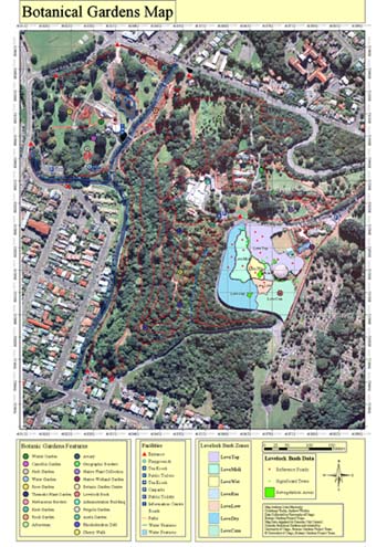
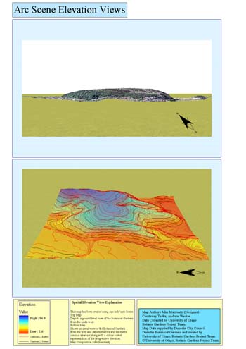
- With two colleagues, proposed, designed and created a Prototype Spatial Information System
for the Dunedin Botanic Gardens. The objective of creating
the Spatial Information System was to provide the Gardens with an
intuitive and efficient way of storing, querying and viewing data
associated with important attributes of their plant collections.
Highlights of the project included historical querying capabilities to
visualize where plants, garden beds, monuments and other assets had been
located throughout the long history of the gardens including 3D fly-throughs.
Related Publications and Presentations
-
Teska, C. (2000), Field Test of Integration of Palm
Computer-Collected Data with a Geographic Information System Database for
the Republic of Indonesia, in 'Proceedings of the12th Annual Colloquium of
the Spatial Information Research Centre, University of Otago, New Zealand',
pp. 253-258
-
Guest lecturer: UW-Parkside Geography 110 and 330, 2000
-
Poster Presentations: Australasian User Interface
Conference, 2001; 12th Annual Colloquium of the Spatial Information Research
Centre, 2000; University of Wisconsin System Research Symposium, 2000
I'd like to give my deepest thanks to the
University of Otago staff and students,
to
Rotary International and Rotary District
6270 for selecting me for the 2001 - 2002
Rotary
Ambassadorial Scholarship and to
Rotary District 9980 for
hosting me while in New Zealand.
|